
Drone mapping has revolutionized the way we collect spatial data, offering unprecedented accuracy and efficiency. In many cases you can use a drone to mitigate risk. However, it is not a risk free activity. The use of drones for mapping introduces a myriad of risks that must be managed carefully to ensure successful operations. In this comprehensive article, we will delve into the primary risks associated with drone mapping: regulatory violations, drone crashes, airspace risks and privacy invasion. At a minimum these topics present a financial or legal risk to the operator and at worst they present safety risks to the public. Understanding and mitigating these risks are crucial for anyone involved in the field of drone mapping.
E2 Spatial is located in the United States so this article is written from that standpoint. E2 Spatial does not give legal advice. This article is a general overview of risks to be aware of, when in doubt contact a specialty lawyer.
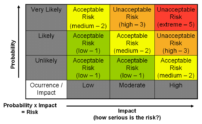
Risk Matrix
No discussion about risk is ever complete with out a risk/probability matrix. The matrix helps you evaluate the risk you are taking by comparing the probability of an event occurring and the impact the event will have. As you can see, an event that has a high impact and is very likely to happen should be considered an unacceptable risk. On the opposite end of the spectrum, an unlikely event with low impact is definitely an acceptable risk. Before a flight every operator should evaluate all their known risks for the probability of occurrence and how serious the impact would be.
Regulatory Violations
Drone operations are governed by a complex web of regulations that vary by country and even region. Regulatory bodies such as the Federal Aviation Administration (FAA) in the United States and the European Union Aviation Safety Agency (EASA) in Europe have established specific rules for drone usage to ensure safety and security. It goes with out saying that regulatory violations are completely avoidable and are not a risk a pilot should even consider taking.
Common Regulatory Violations
Flying Without a License: The United States requires all people who are operating a drone commercially to have a Part 107 Pilot Certificate . If you are making money and do not have a Part 107 certificate, you are flying with out a license.
Flying in Restricted Areas: This includes both airspace restrictions and ground restrictions. In the U.S. the FAA controls the airspace above you and there can be a wide range of restrictions to that airspace. One thing many people don’t realize is that federal, state and local governments can also restrict a drone from taking off or landing inside their jurisdiction.
Exceeding Altitude Limits: Most regulations set a maximum altitude for drone flights, typically around 400 feet. However that altitude restriction could be lower depending on where you are flying.
Overlooking No-Fly Zones: Ignoring temporary or permanent no-fly zones established due to events, security concerns, or other reasons. This is especially true for anything related to crowds or gathering of people.
Lack of Insurance: Operating without the necessary insurance can lead to severe financial and legal consequences. Insurance can mitigate a lot of financial risk the operator assumes, but doesn’t insulate you from the legal risks.
Crashes
There are many things that cause a drone to crash. Pilot error, technical malfunctions, environmental factors and interference can all cause a crash. The fact is crashing your drone is the most likely event that you will encounter. However there are several steps you can take to mitigate the risk. Safe and careful flying, checklists, regular maintenance and insurance are all mitigations you should consider.
Technical Malfunctions are probably the most common problems you will encounter. You are flying an early stage technology that until recently was a project in someone’s garage. Reliability has come a long way in recent years but because of a number of factors we are far from having 100% reliable aircraft. The best thing to mitigate risk is to buy a platform that has a reputation for reliability. The next best thing you can do is regular maintenance on your aircraft. As the saying goes, an ounce of prevention is worth a pound of cure.
Pilot Error is the next most likely risk you will encounter. Whether you are a brand new pilot or you have 1,000 plus hours under your belt – pilot error is a real possibility. Flying conservatively and in a repeatable manner goes a long way to flying safely. You should also consider preflight checklists to ensure that all critical tasks are performed.
Environmental Factors including weather conditions such as high winds, rain, or obstacles like trees and buildings. Just like regulatory violations, environmental factors are mostly avoidable risk. When an environmental factor causes a crash, in hindsight most people will think of it as a pilot error. The best way to avoid this risk is the same as for pilot error. Careful planning and slow, methodical operations will go a long way.
Interference including signal interference from other electronic devices or loss of GPS signal. Sometimes this risk is apparent and sometimes not. If you are flying around a lot of buildings or similar objects you can expect a lot of radio interference. GPS signal is a very complex issue with a lot of different factors. However you can assume you will have GPS problems if you are flying with something obstructing some or all of the sky.
In the end some crashes are preventable and others are not. While you are “in the moment” it is best to already be prepared. Pilot training and a set of emergency procedures are the best way to react to an in flight emergency. Remember you are a professional pilot and emergency procedures are a bedrock of any professional pilot. In the end a drone crash is a major financial risk to the operator – having the correct insurance goes a long way to mitigating the financial loss.
Airspace Risk
Collision Risks
Drones share the airspace with manned aircraft, birds, and other UAVs. The risk of collision can lead to severe accidents. This is the highest, most massive risk that you take when you leave the ground. Every time you take off there is a less than 0% possibility that you could collide with an aircraft and seriously injure the occupants of that aircraft.
Integration with Other Airspace Users
Communication When you are flying in an area with other aircraft at a minimum you should be listening to the local CTAF frequency. “Use of the appropriate CTAF, combined with a visual alertness and application of the following recommended good operating practices, will enhance safety of flight” – FAA
Monitor ADS-B Many new drones come with the ability to monitor ADS-B transmissions from aircraft. If you do not have this capability it is highly recommended to use an ADS-B monitoring app like Flight Radar 24. Flight Radar 24 doesn’t give you complete coverage and may be less than real time, but it is better than nothing.
Separation Obviously the best way to avoid a collision is to separate yourself from the other aircraft. You can be separated either by Time or Space. Obviously being separated by time is the safer of the two. Separating yourself by time means you won’t even be in the air when that plane flies over. Separation by space means you will have a distance between yourself and the plane while both of you are in the air. This obviously requires more coordination and attention.
Privacy
Legal and Ethical Aspects of Privacy
The use of drones for mapping can inadvertently lead to the invasion of privacy. Capturing images or data from private properties without consent can result in legal actions and damage to reputation. Beyond legal ramifications, ethical considerations are paramount. Respecting individuals’ privacy and operating transparently builds trust and credibility.
Best Practices for Privacy Protection
Conduct Privacy Impact Assessments Evaluate potential privacy risks before commencing operations. An ounce of prevention is worth a pound of cure.
Establish Clear Policies If you do collect personal information you need to create and enforce policies on data collection, usage, and storage. These policies need to be transparent and available to the people involved.
Obtain Consent Where possible, seek consent from individuals whose data may be captured. This is the easiest mitigation if the data must be collected.
Minimize Data Collection Only collect data necessary for the mapping project.
Implement Data Security Measures Protect collected data against unauthorized access and breaches. This one seems obvious, but how many of us have had our personal information lost to data leaks? This might actually be the thing most people are worried about when it comes to privacy.
Conclusion
Drone mapping offers transformative potential for various industries. It creates a reduction of risks but is not a risk free activity. Those risks require careful thought and management. Regulatory violations, privacy invasion, drone crashes or failures, and airspace risks are all significant concerns that must be addressed to ensure safe and effective operations.
By staying informed about regulations, respecting privacy, maintaining equipment, and understanding airspace classifications, drone operators can mitigate these risks and leverage the full potential of drone mapping technology. As the industry continues to evolve, ongoing education, adherence to best practices, and technological advancements will play critical roles in managing the inherent risks associated with drone mapping.
